
Santa Clarita Previous Residents Sources
An address history is assembled in layers. The assessor and GIS fix the current parcel; the recorder supplies the legal transfer trail; directories and census schedules suggest household presence; permits and maps explain physical change. None alone proves that a named person lived at the site. The era table separates those roles and marks the access path, including the gaps in online coverage that matter when tracing Santa Clarita previous residents.
| Source | Years It Covers | Where Held | What It Shows |
|---|---|---|---|
| Recorded deeds and grantor/grantee index | 1851-present | RR/CC Norwalk and mail order | Parties, instrument, book-page, legal description |
| Newhall Sanborn map | 1892 | SCVHistory | Buildings, functions, owners, old street names |
| Phone and city directories | Discrete 1923, 1929, 1957, 1958, 1969 volumes | SCVHistory and library | Names, address, phone, community clues |
| Federal census | Through 1950 public in 2026 | NARA and genealogy access | Household names, relationships, address context |
| Assessor and GIS | Current parcel record | County and City portals | AIN, legal description, year built, old AIN, annexation |
| City permits | Online span; exact historical start not stated | Accela and Permit Center | Applications, work dates, address, participants |
Use deeds for ownership, directories and census records for household leads, and permits for structural change. A missing year is normal in Santa Clarita research. The verified directory chronology is discrete, so label blank periods unverified.
Note: A recorder index entry identifies a recorded transaction, not proof that a past owner or occupant stayed at the address.
Santa Clarita Previous Residents Deed Trail
Begin with the current AIN and legal description in the Los Angeles County Assessor Portal and the parcel outline in the Assessor GIS viewer. Add a known current deed party when available. Public assessor detail has no owner-name search and omits owner identity and mailing address, so the parcel key must carry the research between systems.
| Assessor control | Type | Required | Notes |
|---|---|---|---|
| Search by AIN or Address | Tab and text | Yes | Exact address or ten-digit AIN works best |
| Assessment Legal Description | Tab and text | Yes | Alternative legal-description mode |
| Search | Button | Not applicable | Broad queries may cap at 501 results; no export observed |
Address → AIN and legal description → known deed party → grantee index → prior grantor → earlier grantee
- Record the AIN, legal description, tract or lot, current situs, old AIN if shown, and annexation field.
- At Norwalk, choose the recording year and alphabetical grantee index. Record the grantor, instrument or book-page, year, and legal description.
- Search that seller as a grantee in earlier years. Compare the legal description at every turn.
- Repeat the seller-to-buyer loop. RR/CC does not search its deed index by street or APN.
- For older entries, use office-held index and deed material. Keep source notes so the chain can be tested.
A deed party may be tied to land without living there. Compare the legal description and instrument details at each step.
- Grantor
- The party transferring an interest in the land.
- Grantee
- The party receiving that interest in the recorded instrument.
- Chain of title
- The linked sequence of recorded transfers used to follow an interest in one parcel backward.
- Legal description
- The formal land description, such as a tract and lot, that can identify the parcel when an old street name changes.
Norwalk Records for Santa Clarita Previous Residents
Los Angeles County RR/CC does not expose a public online real-property index or deed images. The official real-estate records information points researchers to the county process. All 1851-present index work is office-only. Free viewing is by appointment at 12400 Imperial Highway in Norwalk, with 1851-1957 on the lower level and 1958-present on the second floor. The alphabetical index runs by name and recording year, not by street address or APN.
For an office visit, call 800-201-8999 and use option 3 for recorded records questions. The phone line does not perform a name search, and RR/CC does not accept phone requests. The county's viewing instructions describe the counter route, while appointments can be scheduled about two weeks ahead.
The RR/CC mail-request instructions show the fields needed for a county search.
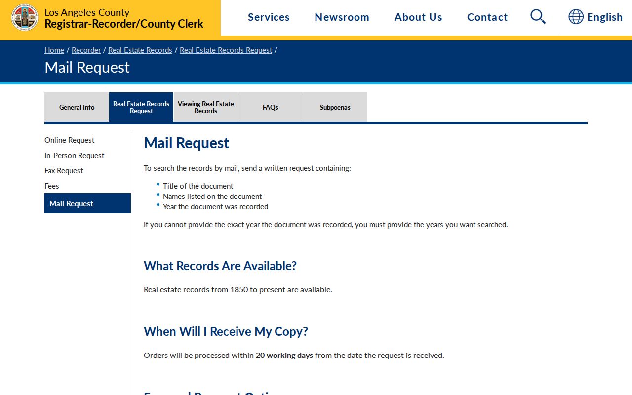
Mail or fax requests need the document title, names listed, and recording years. Send them to RR/CC Real Estate Records, PO Box 1130, Norwalk, CA 90651-1130, with a check or money order. The stated turnaround is 20 working days. A targeted California Public Records Act request for an existing permit or document can supplement the history, but cannot create a deed index or replace RR/CC rules.
Santa Clarita Recorder Fees for Past Residents
Copy orders and index searches are separate from free parcel research. RR/CC lists a plain copy at $5 for the first page plus $3 for each added page. A certified copy is $6 for the first page plus $3 for each added page. A name-and-year search is $0.50 per name and year, with a $1 minimum. Check the county fee schedule before sending payment.
The county fee page separates search charges from plain and certified copy charges.
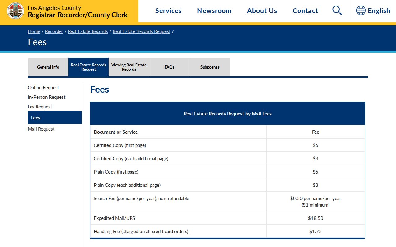
Online county-linked ordering can obtain a copy, but it is not a searchable deed index. For a past transfer, search first, then order the image or copy after the party, year, and instrument are known. Keep plain and certified copies distinct.
Santa Clarita Past Households and Obituaries
Deeds show a transfer party, not every person who used a house. Pair discrete directory volumes with the federal census and newspaper record. The collections are described on the Santa Clarita Directory Book page. The Santa Clarita Public Library provides local-history help, while the FamilySearch catalog points to genealogy holdings. The Signal archive runs 1919 through 2015, has more than 520,000 searchable pages, and is available through the library or library Wi-Fi.
- Record today's exact address, AIN, legal description, community name, and any old street spelling.
- Search a directory year by surname, then inspect the address or reverse portion. Copy the wording, phone, community code, and nearby entries.
- Match the lead to the nearest census year through 1950. Compare household relationships and address context, allowing for enumeration boundaries.
- Use The Signal, an obituary, deed, or permit as a second anchor. Mark a name as a lead when one source stands alone.
Obituaries may supply family, former community, or last address clues. They can show why a household disappears from a directory. A census entry is one enumeration and a directory entry is one snapshot; neither fills every year between them.
Note: The 1969 directory predates incorporation and covers Newhall, Saugus, Valencia, and Canyon Country as separate local terms.
Santa Clarita Previous Residents and Old Names
Before December 15, 1987, the component communities were unincorporated. Earlier directories, newspapers, maps, and census references may be filed under Los Angeles County, Newhall, Saugus, Valencia, or Canyon Country. Search all four names when a house predates the city. The 1969 local volume intentionally serves those communities.
Newhall moved about two miles south in January 1878 toward water. Spruce was realigned in the 1920s, became San Fernando Road, and its downtown segment became Main Street in 2007. Tenth Street and Pico Road became Lyons Avenue; Fir became Walnut; Maple became Chestnut. The SCVHistory map catalog bridges plats, railroad property, subdivisions, and aerial views.
Research found no verified Santa Clarita-wide street-renumbering year or courthouse disaster that destroyed the county's core records. A mismatch calls for a tract, lot, block, deed description, map, directory cross-reference, or USPS check, not forced current geocoding.
Santa Clarita Previous Residents 1957-1958
The 1957 and 1958 telephone volumes are snapshots, not a continuous run. The January 1957 book covers Newhall, the Santa Clarita Valley, Lake Hughes, Palmdale, and Lancaster. The January 1958 volume is titled for Newhall and the Santa Clarita Valley. Both were Pacific Telephone and Telegraph publications tied to 24275 North Walnut Street.
The 1957 volume can narrow a surname, community, phone number, or street spelling before the deed chain is checked. It is a dated directory snapshot, not proof that every household member lived there.
The 1958 Newhall telephone directory preserves a second nearby snapshot for comparison.
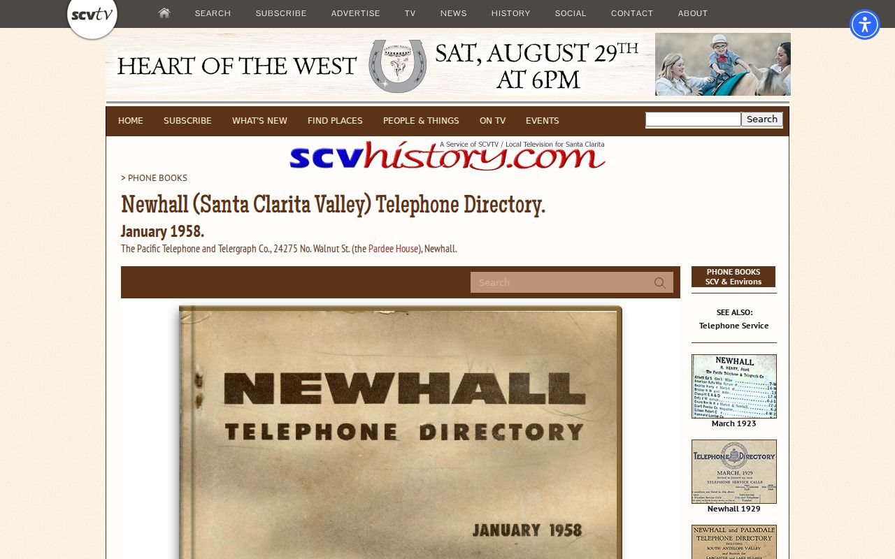
Compare the years for a changed number, moved entry, or community label, then test the lead against a deed, census household, newspaper notice, or map. A change between 1957 and 1958 does not explain every year between them.
Santa Clarita Past Residents on Old Maps
The 1892 Newhall Sanborn map adds a physical layer. It identifies some owners and building functions, records construction material and fire or water infrastructure, bridges old street labels, shows the Railroad and Market depot, and places a school near Fir and 9th. SCVHistory also holds early plats, railroad property records, subdivisions, and aerial views.
Use the map to test whether a building, lot, or block existed in the expected place, then connect it to a legal description, directory, or instrument. A Sanborn sheet explains a street mismatch, but it is not a census or proof of occupancy on every date.
Note: Old maps are strongest when block, building, owner, and legal-description clues agree across at least two independent record types.
Santa Clarita Previous Residents and Permits
Permits can date a repair, inspection, or other change at a Santa Clarita address. The Santa Clarita Accela eService portal offers Property Information and searchable Building, License, and Environmental Services areas. The City Permit Center is the counter route. The exact historical start of online records is not stated, so an empty result proves little.
Search the most precise field, then ask for an existing file or log through the Santa Clarita City Clerk public-record request channel. Identify the address, date range, record number, project, or department. CPRA access concerns existing records and may involve redaction; it does not require a new address history.
| Field or control | Type | Required | Format or use |
|---|---|---|---|
| Record or application number | Text | No | Best precision when known |
| Street number and street name | Text pair | No | Address-keyed search |
| Parcel number | Text | No | Bridge to the assessor parcel |
| Start date and end date | Date pair | No | Narrow the application period |
| Search and reset | Buttons | Not applicable | Run or clear the query |
Year-built and work-date fields support a house timeline, but do not establish occupancy or a sale. Applicants, contractors, service agents, and deed parties are separate categories.
Santa Clarita Probate Leads for Past Residents
Probate and obituary records can close a trail when an earlier owner or household member dies. Wills and probate cases belong to the Los Angeles Superior Court, not RR/CC. The Los Angeles Superior Court case-access portal can point to a probate index; sealed or confidential records may require courthouse access or clerk copies.
Search an obituary under the full name and each known community, then compare family or last-address clues with directory and deed notes. The Signal archive can bridge a gap, but library and library-Wi-Fi limits apply. Probate or obituary evidence may explain a name change or estate transfer without proving later occupancy.
Lawful house history. Use Santa Clarita records for family history, heir research, and the history of a house. Do not use names, addresses, or record links to stalk, harass, threaten, or track a living person. California Penal Code section 646.9 treats stalking as a serious legal matter, and a public record is not permission to intrude.
A careful result can end with an honest gap. Record the last supported date and why a later period cannot be confirmed.